Locating Groundwater is a Science and an Art. It Requires a Basic Understanding of Hydrogeology, Observation, and Inquiry
Locating groundwater is a science and an art. It requires a basic knowledge of hydrogeology, as well as, observation and inquiry.
Much of the contents on this page has been adapted from publications of Lifewater International, written by Fred Proby.
As mentioned in the section on groundwater sources , groundwater flows from a recharge area to a discharge point. Generally, the discharge point is at a lower elevation than the recharge area. So, groundwater generally flows from a higher elevation to a lower elevation.
Discharge points may be a spring or the bed of a river or stream. Groundwater may also discharge along the shore of a lake or beneath a lake or ocean. So, we may find groundwater closer to the surface if we drill near streams, rivers or lakes.
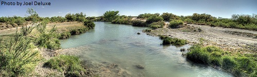
Groundwater generally follows the contours of the surface of the ground. We may be more successful locating groundwater if we drill a well at the bottom of a low point, such as a ravine, rather than at the top of a mountain.
Generally we want to look at the lower elevations of the surrounding topography, like in valleys, basins, or ravines, and also near rivers, streams, lakes, or ponds.
With these things in mind, here are some clues to look for and questions to ask in locating groundwater through observation and inquiry.
1. Where are people presently getting their water?
2. Hand dug wells found nearby will show the depth to groundwater and the type of sediment in the area.
3. Are there drilled wells in the area? Perhaps the village or responsible government agency has useful information on the well, such as its depth and the sediment or rock types encountered when the well was drilled.
4. Groundwater can often be found in sand or gravel layers in the bottom of a valley, even if those layers are covered by layers of silt or clay. Groundwater in valleys or low-lying areas is often closer to the surface than in steep or relatively high areas.
5. Are there springs in the area? Groundwater can usually be found nearby. If a spring flows all year, it is likely to come from a productive aquifer. If the spring dries up, then it might be overflow from a perched aquifer, but still worth exploring.
6. Are there streams in the area? Carefully observe stream flow, looking for sections where flow is greater and sections where flow is less. Where it is greater, groundwater may be discharging into the stream, indicating a good area to drill. Even dry stream beds often have shallow groundwater underneath.
7. Trees or shrubs that remain green in the dry season may have roots that reach into the groundwater at a relatively shallow depth. Greener patches of grass may reveal places where groundwater is close to the surface.
8. Pay attention to where animals go to find water. Bees and pigs are very good at finding water.
9. Look for deposits of salt or other minerals – usually visible as a white “crust” on the surface of the ground. These may be caused by the evaporation of groundwater, which leaves the minerals behind. A large surface deposit might indicate that the ground water has a very high mineral content.
10. Look for “outcrops” of tilted layers of rock on hills or ridges; groundwater will flow downhill along the direction of tilt.
11. Some rock layers, like sandstone or limestone, have many cracks. These may produce acceptable quantities of water.
12. Examine any outcrops of marble or limestone that are being used for building materials. Some can be good aquifers. But remember that not all drilling techniques can penetrate rock.
13. Do not limit your investigation to a small area. It is desirable for a well to be as close as possible to where people live, but it is more important that it produces a sufficient quantity of water.
Geophysical Methods of Locating Groundwater
Geophysical methods of locating groundwater are technological ways of determining conditions below the ground surface without actually drilling a hole.
These techniques are most commonly used when exploring for and locating groundwater in hard crystalline rock areas, but they can also be used to assist in areas of unconsolidated sediments.
Each of these geophysical techniques measures a specific physical property of the rock or sediment such as the earth’s electrical resistance, electrical conductance, density, and magnetic properties. Changes in these properties can be related to changes in the type of sediment or rock, potential for aquifers, and in some cases groundwater quality.
However, each of these geophysical methods has limitations. These techniques cannot, by themselves, determine the presence and location of an aquifer. Data developed by geophysical methods must be compared with nearby known geology to be accurately interpreted.
Examples of geophysical methods that can assist in locating groundwater include electrical resistivity, seismic refraction. Commercial resistivity and seismic instruments are available, but their cost may range from $10,000 to $20,000 each.
Electrical Resistivity – A resistivity survey measures the electrical resistance to a current induced into the ground.
The electrical resistance of sediment or rock depends on many factors such as particle size, porosity, density, mineral and chemical composition, and moisture level. Resistivity data can reveal something about these factors and the geological composition of the area being measured.
Seismic Refraction – A seismic refraction survey measures how fast a “shockwave” travels through the ground.
Because the waves travel at different speeds depending upon the density of the material they pass through, the timing of their arrival at the geophone can be interpreted to reveal something about the density of materials at different depths.
Considering the expense and complexity of geophysical methods discussed above, and the relative simplicity afforded by observation, inquiry, and a basic knowledge of hydrogeology, these simpler methods are often a more practical approach to locating groundwater.
Return to "Groundwater" from "Locating Groundwater"
Return to "Home"